BHR-53
Brit-Am Historical Reports
13 October 2010 5 Cheshvan 5771
Contents:
1. Mapping Ancient Germania. Berlin Researchers Crack the Ptolemy Code.
By Matthias Schulz
2. Amnon Golberg: Germans dangerous in retreat
3. Archaeology: Brit-Am Version of Explorator 13.25.
|
Brit-Am Discussion Group |
Contents by Subject |
Research Recognition Reconciliation Contribute |
|
Site Map Contents in Alphabetical Order |
This Site |
1. Mapping Ancient Germania
Berlin Researchers Crack the Ptolemy Code
By Matthias Schulz
Extracts:
|
A 2nd century map of Germania by the scholar Ptolemy has always stumped scholars, who were unable to relate the places depicted to known settlements. Now a team of researchers have cracked the code, revealing that half of Germany's cities are 1,000 years older than previously thought.
The founding of Rome has been pinpointed to the year 753. For the city of St. Petersburg, records even indicate the precise day the first foundation stone was laid.
Historians don't have access to this kind of precision when it comes to German cities like Hanover, Kiel or Bad Driburg. The early histories of nearly all the German cities east of the Rhine are obscure, and the places themselves are not mentioned in documents until the Middle Ages. So far, no one has been able to date the founding of these cities.
Our ancestors' lack of education is to blame for this dearth of knowledge. Germanic tribes certainly didn't run land survey offices -- they couldn't even write. Inhabitants this side of the Rhine -- the side the Romans never managed to occupy permanently -- used only a clumsy system of runes.
According to the Roman historian Tacitus, people here lived in thatched huts and dugout houses, subsisting on barley soup and indulging excessively in dice games. Not much more is known, as there are next to no written records of life within the barbarians' lands.
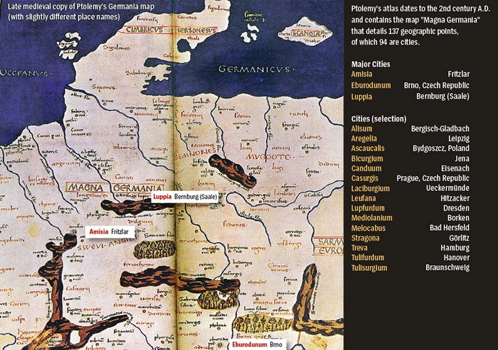
That may now be changing. A group of classical philologists, mathematical historians and surveying experts at Berlin Technical University's Department for Geodesy and Geoinformation Science has produced an astonishing map of central Europe as it was 2,000 years ago.
The map shows that both the North and Baltic Seas were known as the "Germanic Ocean" and the Franconian Forest in northern Bavaria was "Sudeti Montes." The map indicates three "Saxons' islands" off the Frisian coast in northwestern Germany -- known today as Amrum, Foehr and Sylt.
It also shows a large number of cities. The eastern German city that is now called Jena, for example, was called "Bicurgium," while Essen was "Navalia." Even the town of Forstenwalde in eastern Germany appears to have existed 2,000 years ago. Its name then was "Susudata," a word derived from the Germanic term "susutin," or "sow's wallow" -- suggesting that the city's skyline was perhaps less than imposing.
This unusual map draws on information from the mathematician and astronomer Ptolemy, who, in 150 AD, embarked on a project to depict the entire known world. Living in Alexandria, in the shadow of its monumental lighthouse, the ancient scholar drew 26 maps in colored ink on dried animal skins -- a Google Earth of the ancient world, if you will.
One of these drawings depicts "Germania Magna," the rainy realm inhabited, according to Roman sources, by rough barbarians whose reproductive drive, they said, was giving rise to an alarming number of tribes.
Ptolemy demonstrated extensive knowledge of this remote area, indicating the locations of mountains, rivers and islands. An index lists 94 "poleis," or cities, noting their latitude and longitude accurately to within a few minutes.
The map shows settlements as far afield as the Vistula River in present-day Poland, where Burgundians, Goths and Vandals once lived, and mentions the Saxons for the first time. It appears Ptolemy was even familiar with the Swina River, which flows from the Szczecin Lagoon into the Baltic Sea, near the present day German-Polish border.
The essential question is whether the new data is accurate. Ptolemy's "Geography" is preserved only in duplication. The copy so far considered the most authentic is an edition produced around the year 1300 and kept by the Vatican.
But the team of experts in Berlin had the great fortune to be able to refer to a parchment tracked down at Topkapi Palace in Istanbul, Turkey, the former residence of the Ottoman sultans. The document, consisting of unbound sheepskin pages with writing in Roman capital letters, is the oldest edition of Ptolemy's work ever discovered. A reproduction of this version is due to be published next year.
2. Amnon Golberg: Germans dangerous in retreat.
FRIDAY OCTOBER 8, 2010
TISHRI 30, 5771
www.jewishtelegraph.com
REGARDING the letter headed God showed Nazis He was in charge, it is remarkable that Hitler's fortunes went in to decline only once he commenced the Holocaust in the summer of 1942.
Just as remarkable was the Nazi ability to hold out against the whole world for another three dreadful years, giving them time to accomplish the goals of the Wannsee Conference.
The Allies repeatedly found to their cost that Germans in retreat were as dangerous as cornered Bavarian timber-wolves, learning in full the meaning of gegenangriff (counter-attack) at Dieppe, Kharkov, Kasserine, Kursk, Ploesti, Dodecanese, Anzio, Monte Cassino, Carentan, Operation Rosselsprung, Cherkassy, Arnhem, Aachen, Narva, V rockets, Targul Frumos, Wilkowischken, Battle of the Bulge, Hurtgen Forest, Strasbourg, Operation Steinbock, Lake Balaton etc.
Two thousand years ago, the Talmud warned: "Should Germania ever sally forth, it will destroy the world" (Megillah 6).
And Germany is listed in Ezekiel 38 as one of the confederates that will attack Israel in the future war of Gog and Magog
Amnon Goldberg
Safed
Israel
3. Archaeology: Brit-Am Version of Explorator 13.25.
From: david meadows <rogueclassicist@gmail.com>
================================================================
explorator 13.25 October 10, 2010
================================================================
Taygete Atlantis excavations blogs aggregator:
http://planet.atlantides.org/taygete/
================================================================
EARLY HUMANS
================================================================
... and another revisionist view of Neanderthals (revisionist from, say, 20
years ago) that doesn't seem to be directly connected to the previous:
http://www.washingtonpost.com/wp-dyn/content/article/2010/10/04/AR2010100405818.html
================================================================
ANCIENT NEAR EAST AND EGYPT
================================================================
Byzantine mosaics from Tel Shikmona (we had this a month or so ago, no?
possibly
an update):
http://newmedia-eng.haifa.ac.il/?p=3649
Finds from various periods found by a team from WLU at assorted sites in
Jordan:
http://www.exchangemagazine.com/morningpost/2010/week39/Friday/100117.htm
http://digs.bib-arch.org/digs/khirbat-al-mudayna.asp
http://www.wlu.ca/homepage.php?grp_id=906&ct_id=770&f_id=35
... and the dig has a facebook page:
http://www.facebook.com/group.php?gid=199188024446
Plans to somehow 'breach' the Western Wall and expand the plaza (this has
saga potential):
http://www.haaretz.com/print-edition/news/j-lem-considers-tunnel-entry-to-western-wall-plaza-1.317011
http://www.jpost.com/Israel/Article.aspx?id=190226
http://www.israelnationalnews.com/News/News.aspx/139922
http://www.haaretz.com/print-edition/news/will-the-walls-of-the-old-city-of-jerusalem-be-breached-for-first-time-in-a-century-1.317387
http://www.jpost.com/Israel/Article.aspx?id=190642
More on the latest pyramid theory:
http://www.newkerala.com/news/world/fullnews-49886.html
Dr Leen Ritmeyer's Blog:
http://blog.ritmeyer.com/
Paleojudaica:
http://paleojudaica.blogspot.com/
================================================================
ANCIENT GREECE AND ROME (AND CLASSICS)
================================================================
Not sure we had news coverage when this ship was found off the coast of
Cyprus four or so years ago:
http://www.msnbc.msn.com/id/39536298/ns/technology_and_science-science/
http://www.global-adventures.us/2010/10/08/ancient-cultures-ship-wreck/
http://www.livescience.com/history/ancient-mediterranean-shipwreck-nautical-archaeology-101006.html
Feature on assorted Lycian sites:
http://www.todayszaman.com/tz-web/news-223948-117-coasting-the-mediterranean-in-the-footsteps-of-the-lycians.html
Someone seems to be looking at Roman life expectancy from very old studies:
http://blogs.discovermagazine.com/gnxp/2010/10/ancient-rome-as-a-death-pit/
Spartacus turns 50:
http://www.washingtonpost.com/wp-dyn/content/gallery/2010/10/07/GA2010100702683.html
... and folks are pondering why his story is so interesting:
http://www.thoughtleader.co.za/bertolivier/2010/10/06/why-is-the-history-of-spartacus-so-endlessly-fascinating/
Finally ... someone gets that America-as-Rome thing right:
http://krugman.blogs.nytimes.com/2010/10/03/roman-projections/
A feature on Schliemann:
http://www.investors.com/NewsAndAnalysis/Article/549229/201010041649/Heinrich-Schliemann-Dug-Deep-To-Excavate-Cities.aspx
Oh oh ... looks like someone spilled the beans:
http://www.theonion.com/articles/historians-admit-to-inventing-ancient-greeks,18209
A top-ten-books-on-the-ancient-world list:
http://www.guardian.co.uk/books/2010/sep/29/annabel-lyon-top-10-books-ancient-world
Visit our blog:
http://rogueclassicism.com/
================================================================
EUROPE AND THE UK (+ Ireland)
================================================================
On the DNA front, latest tests have confirmed which bacterium caused the
'Black Plague':
http://www.sciencedaily.com/releases/2010/10/101008112420.htm
http://uk.news.yahoo.com/18/20101008/tsc-bacteria-confirmed-as-culprit-in-bla-c2ff8aa.html
================================================================
ASIA AND THE SOUTH PACIFIC
================================================================
Bronze Age 'Aryan' sites from the Russia/Kazakhstan border:
http://www.theaustralian.com.au/news/world/unearthed-aryan-cities-rewrite-history/story-e6frg6so-1225933563131
http://mmail.com.my/content/51206-4000yearold-aryan-city-discovered-russia
http://www.thehindu.com/2010/10/05/stories/2010100557652000.htm
Medieval (?) burials from Russia:
http://english.ruvr.ru/2010/10/06/24434824.html
Very interesting slideshow on the similarities between Orthodox Christian
and Tibetan Buddhist art:
http://www.huffingtonpost.com/2010/10/03/striking-similarities-bet_n_748626.html#s149462
================================================================
OTHER ITEMS OF INTEREST
================================================================
The mathematics of poetry:
http://www.theatlanticwire.com/features/view/feature/How-Pascals-Triangle-Explains-Poetry-2264
Linguistic drift:
http://galvestondailynews.com/story/182570
I have no idea where to classify this one: a Salafi preacher has issued a
bizarre fatwa on the sale of antiquities:
http://www.almasryalyoum.com/en/news/public-outcry-after-salafi-preacher%E2%80%99s-fatwa-antiquities
On the origins of assorted car company names/logos (including Volvo!):
http://autos.yahoo.com/articles/autos_content_landing_pages/1532/true-stories-behind-car-company-logos/
================================================================
CRIME BEAT
================================================================
They're (finally) pondering a verdict in the Oded Golan case:
http://www.aolnews.com/world/article/judge-considers-verdict-in-jesus-forgery-case/19659376
http://www.jpost.com/Features/InThespotlight/Article.aspx?id=190495
================================================================
EXHIBITIONS, AUCTIONS, AND MUSEUM-RELATED
================================================================
Lost World of Old Europe:
http://www.ana.gr/anaweb/user/showplain?maindoc=9173848&maindocimg=9174398&service=144&showLink=true

Pleased with what you have read?
Click Here to make an offering. |
'It is impossible to rightly govern the world without God or the Bible.'
George Washington
Brit-Am is the "still small voice" that contains the truth.
[1-Kings 19:12] AND AFTER THE EARTHQUAKE A FIRE; BUT THE LORD WAS NOT IN THE FIRE: AND AFTER THE FIRE A STILL SMALL VOICE.
 |
 |

